Online GIS for website, blog and FB
 TINYRAY Geographic Information Service (tnGIS) provides both map and street visualizations of locations and regions which are embeddable to your website, blog and FaceBook fan page. tnGIS is free for personal use and is available online at:
http://www.tinyray.com/geoip.
- The first step is to enter the location information such as a mail address, landmark name or Internet Protocol (IP) address under the “IP or Street address” box, then select either the “MAP” command, which visualizes the location map, or “Street View” command which visualizes the street view by this location. tnGIS can help with adjusting the location input, the information entered is therefore not required to be completely exact.
- On receiving your input, tnGIS will search for the location, collect its approximate information and display on the web page. If the information found closely describes the location then it is good to go to the next step.
- To set a title or name to the location, please enter it carefully under the “Location” input box then select the “used as title” check box. A video about the location, if available on Youtube, can also be added by entering the video ID using TINYRAY Entertainment URL format under the “Embedded media” box.
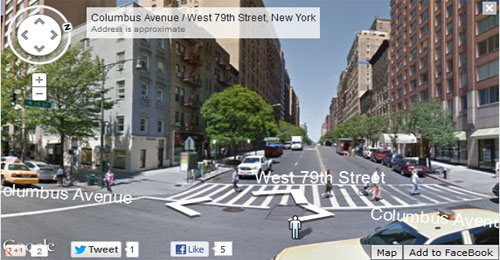
- Again, select either the “MAP” or “Street View” command to confirm your input. If a video was attached, please select the “On” command to preview it in-place.
- The last step is to adjust the view on the location,
- In the Street view mode- click the street arrows to move or rotate the wheel to change the point of view.
- In the Map view mode- drag the marker to adjust the location.
Now, you can select the “<code>” command to get the embedded code of the location visualization for your website or blog, or select “Add to Facebook” command to place it on your Facebook fan page.